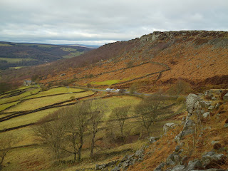
A walk starting at Curbar Gap high up above Baslow across heather moors, pass Eagle rock, wellington monument, Nelsons monument, three flagships and gibbet moor.
 |
| Curbar Gap and the starting point on Baslow Edge looking towards Curbar edge. |
Starting at the top of Curbar Gap just off the A623. Start with the car park at your back and cross over the road and up the small incline to the gate on to Baslow edge go through the gate on to baslow Edge. There are two paths take the one to your right and head towards the edge for the spectacular view point over Baslow looking towards Eyam, Win Hill and Kinder Scout Plateau. From the view point follow the path along through the rock edge all the way around joining back to the other path.
 |
| The view from Baslow Edge looking at Baslow |
 |
The footpath over Baslow Edge through the rocks.
|
Were the paths join you can double back to your left to see the 20 foot high Eagle rock, local legend was that those who could climb the rock would be strong and virile and so local men would have to climb the rock before being allowed to marry. However continue along the path bearing to your left and head to the wellington monument.
 |
| Eagle Rock |
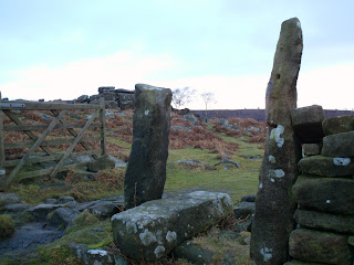
At the monument follow the path along and round to your left over the small river and pass the small wood and follow the old coach road past the old chesterfield roade marker and to the road.
|
Old chesterfield cart roade sign.
|
 |
Old Chesterfield cart roade.
|
Turn right to the cross roads and the bridge over the stream. At the cross roads look to your left along the river and the edge you can see is Gordoms Edge and this is the line you will be following. Cross straight over the road and go through the gate on your right into the fields. Here there are three paths to choose from, the path to your left takes you up to the top of Birches Edge and this is the path you will come back down on, the middle takes you along the bottom of the edge and the third path to the right is one you will take to go over Gordoms Edge. Walk along Gordoms Edge following the path through the heather moor. At the start of the rocks edge go through the gate on your right and continue to follow the path along the the cliff edge.
 |
| Gordoms Edge in front of you to the left hand side. |
Walk along the edge until you come to a collapsed wall with a gate on your left do not go through the gate but continue through the gap in the wall and along the edge after a while following this path you will come to a junction of paths to your left and right. Take the path to your left through th stone post and walk diagonal through the field with the small rock formation on your left hand side. While walking through this field look to your left and you can see Birchens Edge and the three Flagships on the horizon. Follow the path diagonally through the field all the way down to the main road and over the style. Here in front of you is the footpath to go onto Chatsworth grounds and the hunting tower or gibbet moor home of Derbyshires last live execution by gibbeting.
 |
| The path to your left after Gordoms Edge and back to the main road |
At the main road turn to your left and walk up the road past the Robin Hood Inn a small pub which serve meals at lunch time and evening. Continue past the pub and fork of onto the side road on your left in just a few yards after the first house is a footpath to your left take this path and follow the narrow path along the bottom of the wall and through the trees. If you stay on this path you will walk along the bottom of Birchens Edge and come out the other side back at the cross roads on the middle path. But after a short while look to your right and take the first steep path to your right and up onto Birches Edge. At the top turn right and follow the path along the rock edge looking towards Nelsons monument, erected in 1810 to celebrate Lord Nelson and three rocks known as the flagships.
 |
| The path after Robin Hoods pub up onto Birchens Edge turning left at the top to the Flagships and monument. |
 |
| Birches Edge looking back over Chatsworth and Gibbet moor. |
 |
| The three ships each one carved with the names of Nelsons Flag ships. |
 |
| Nelsons monument erected in 1810. |
Walk past Nelsons monument and follow the path again along the heathered moor to the trigonometry point. At the trig point there are two paths one takes you to your left and back to the main road on the middle path but you will take the one that is straight on and follow this path round the edge of the trees and across the field heading to the corner were the three paths mentioned earlier meet at the main road. Go back through the gate and cross back over the road and double back towards the old chesterfield coach road( from here you could stick to the main road and walk along it back to the car park at Curbar Gap). When you get to the old road there is a path through a gate on the right hand side into the fields take this path and walk diagonally to your left following the path up towards White Edge. As you start to ascend up the field there are a choice of two paths both bringing you out in the same place. Stick to the one on your left as it is flatter and a little easier, walk over the bridge and join the path again heading to your left and up to the foot of White Edge.
 |
| The path from the Old Chesterfield roade on your right upto the foot of White Edge. |
 |
| Looking back over the bridge . |
At the foot of White Edge the is a sign post and choice of paths, For a really long walk follow the path up onto White Edge and walk along white Edge all the way to the back of the Longshaw Estate getting onto the road and walking down to your left until you come to the footpath for Froggats Edge and turn left walking back to Curbar Gap over Froggats Edge and at the rise of rocks on to Curbar Edge and back to the car park. However for this walk at the sign post turn left and follow the path down and up over the bridge back to Curbar Gap car park. Now to enjoy more spectacular views, walk up the clear path on to Curbar and follow the Edge line along Curbar Edge and notice over the edge where a mill stone is left as its been carved from the cliff face as the milling business collapsed over night. At the top of Curbar Edge look to your right and you can see Win Hill, Edale and the Kinderscout Plateau. If you were to continue along Curbar Edge and then Froggats Edge you would come out at Grindleford and the bottom of Padley Gorge both worth a walk aroound in their own rights. From the top of Curbar Edge you can see a Faint path used by climbers Heading down to a wall and then onto the road were cars park. Take this path and at the road turn left back up to the car park at Curbar Gap.
 |
| The footpath from the foot of White Edge back to Curbar Gap and car park. |
 |
| Curbar Edge overlooking Baslow and the signs of a collapsed industry. |
 |
Curbar Edge looking to Baslow Edge and the sign of the footpath along the wall back to the road where the cars are parked.
If the path down to the road looks to awkward then simply double back down the car park at the top of Curbar Gap. Curbar Edge looking towards Froggats Edge and in the distance Win Hill and the Kinderscout Plateau on the horizon. |

This is the view of the Three flagships from Gordoms Edge as you walk through the field towards the main road and the Robin Hoods Inn. This is about a five hour walk and its possible to time this to get to the Robin Hoods pub in time for dinner or alternately stop half way through in a sheltered place for a picnic. This photo was taken at about half way through and there are some shelterd rocks here or continue up to nelson ships for shelter however this is a little more open up there. This a walk up high with uninterupted views over the valleys and the walk can be made shorter easily by coming of the the old Chesterfield Roade path and going straight over the road up to the foot of Whites Edge and walking back to Curbar Gap. Or a really small walk across the Baslow Edge and turning left at the end back past Eagle Rock and straight back to the car park and like wise a small stroll up onto Curbar edge for the views can rewarding.


How long is this walk?
ReplyDelete8 mile
ReplyDelete